DMAP Info

In 2003 the Pennsylvania Game Commission (PGC) instituted the Deer Management Assistance Program (DMAP). This program was developed to help landowners who had high deer density and high deer impact, and for whom regular deer season regulations did not reduce deer density and impact to manageable levels.
3 DMAP of the KQDC
The PCG identifies special DMAP Units: hunters who apply for and obtain DMAP permits may harvest an antlerless deer during legal deer seasons on the lands identified within the DMAP Units. Landowners submit applications to the Pennsylvania Game Commission to have their lands identified as DMAP Units. The applications must justify the need for additional reduction of deer density, request a specific number of antlerless permits, and include maps that direct hunters to the properties and identify boundary lines.
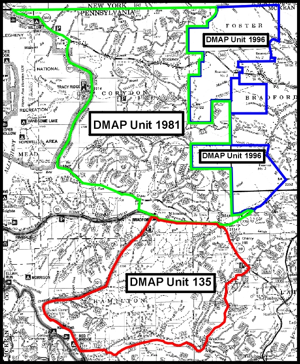
The KQDC obtained two DMAP Unit designations in 2003: DMAP Unit 134 and DMAP Unit 135. Because hunter access, hunter use, deer density, and timber harvest (forage production) were different within DMAP Unit 134, that Unit was split into two Units for 2012: DMAP Unit 1996 and DMAP Unit 1981. DMAP Unit 135 is unchanged.
The items below display the 3 DMAP units of the KQDC. New maps will appear on this page.
The three DMAP Units are:
DMAP Unit 1981 full map (Green border – ANF portion of the KQDC North of State Highway 59);
DMAP Unit 1996 full and DMAPUnit_1996(withtopos) Blue border – Bradford Watershed and Kane Hardwoods lands – eastern portion of KQDC North of State Highway 59;
KQDC DMAP 135 – FIA Portion (Red border – Portion of KQDC South of State Highway 59). Print the KQDC DMAP 135 – FIA Portion in PDF format without additional words